Popularly known in Philippine history as the place
where revolutionaries Gen. Emilio Aguinaldo and Pedro Paterno together with the
members of the Katipunan established the short lived Republic of Biak-na- Bato
complete with a constitution and a set of officers.
Biak na Bato or
broken stone is part of the Philippine Sierra Mountain range. It is heavily forested
and houses several caves with a river running through some of them. The river’s water comes from Calumpit and ends
in Pampanga’s Candaba marsh lands. Declared as a national park in 1937 by
President Manuel l. Quezon, Biak-na-Bato’s 2,117 hectares of hidden beauty
awaits leisure visitors and naturalists alike.
Located in the eastern most section of San Miguel,
Bulacan – Biak na Bato’s highest peak rises
to over 1000 meters above sea level. Formed
mostly with limestone, Biak-na -Bato also treasures its marble attracting quarry
concessionaires who have defaced parts of its façade and adjacent landscape.
The Team:
Hesitant at first, our travel team was composed of two of
my three sons, Franck and Matthew and myself. Both are quite athletic but rarely
try adventure activities other than their daily routine.
The night before, we prepared one back-pack which
contained enough drinking water and sandwiches for three, and a SFO police
issue magnalite (4 D-cell battery flashlight). On a separate bag: extra
t-shirts, light shorts and sandals.
The Saints:
Accessible via the
NLEX , we took the Sta. Rita exit then veered
off to an unmarked by-pass road circumventing
Pullian’s town traffic. We proceeded through the Bulacan towns of Baliuag, San
Rafael (famous for its salted duck eggs and balut), San Idelfonso (poultry
farms), and finally San Miguel -the last town of Bulacan before crossing the
provincial boundary Nueva Ecija.
Initially part of
Pampanga, San Miguel de Mayumo was the original town’s name after its first
town mayor, Miguel Pineda and its holy patron, San Miguel de Arkanghel or St. Michael the Archangel. Mayumo, a Pampangeño word meaning sweet was an
added flavor. Hardly known, San Miguel is famous to travelers traversing
through the Bulacan-Cagayan Valley route for its sweet delicacy, the pastillas de leche or milk pastries in
particular. In the 60’s, these sweet delights were carefully wrapped in thin
Chinese colored paper whose ends were intricately cut out forming lattice-like
designs of flowers or birds. Similar to the tails of our star parol or Christmas lantern then . Not to forget is San Miguel’s native chicharon or deep fried pork rind. Both
of these delicacies are all home cooked available in the town’s small sari-sari
stores or directly in houses where they are prepared. A local entrepreneur made
this home industry into a flourishing business and has promoted San Miguel’s best
under the “Sevilla’s Sweets” retail outlets along San Miguel’s main highway and
in Metro Manila’s malls.
Ancestral
Houses:
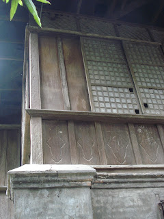
A few old wooden ancestral houses still stand in San
Miguel’s town proper. Victorian inspired, the structures depicts the lifestyle
of the residents who regularly held large gatherings, where the town illustrados danced their way to better
times. Today, these houses are empty, guarded only by relatives of caretakers
past.
For the first time, Franck and Matthew visited their
grandfather’s ancestral home along Viola Street beside the main bridge and town
river. The street was named after Maximo Viola, a close friend of Dr. JoséRizal who financed the printing of his famous novel, the Noli Me Tangere or Touch Me Not. The wooden panels and gapping hard
wood floors are still intact, parched dry from decades of heat, rain, and dust.
Though bearing some cracks due to
torrential rain flooding, its ground level brick walls and posts still tolerate
the load of the aging house.

Route:
After touring the house, we headed east taking the parallel
road next to the old cemetery. The view was a relief from the town’s narrow
roads congested with tricycles emitting exhaust fumes as they ply through the
town proper. The vast landscape of rice
fields occupying both sides of the road was a sight to enjoy. Tough there were
a number of unpaved sections; the road was good at cruising speeds.
Finally, the road ends in the Biak-na-Bato Park. An
entrance fee is required in the park office. Special arrangements for official
guides are available.
We followed our guide, leading us through the main trail beside
the river bank. Several concrete tables and benches are installed along the
river bed’s sides where picnickers can eat as they rest from bathing in the
cool and clear running water.
Unlike other forests, Biak-na- Bato’s trail is pleasantly
cool owing much to its running river beside the pathways.
 We reached the Bahay
Paniki or Bat Cave. Entry is
through a large crevice, leading down to a huge chamber. The river passes
through its high vaulted openings on both ends. Thousands of bats hang on its
ceiling, squeaking and a few flying in pursuit of a better space to cling on to.


The guide narrated how sudden and strong the water gushes
inside the cave and outside during the rainy season once taking a life of an
unsuspecting adventurist.
We exited the cave through the same entry point. We then crossed
the river via the hanging bridge. Across
was another narrow limestone trail which led to a camp ground. While we took a
few minutes rest, our guide prepared a special lantern to light our way in the
next cave. We climbed the nearby hill which led us to the Santol Cave. As in the Bahay
Paniki, the entrance way was trough a gapping hole on the ground. Different
was that this cave was much smaller, super dark, no other openings other than
the entranceway, was quite slippery and muddy. Our guide lit his lamp and led
the way while I positioned myself on the rear lighting the other half of our
tracks. We saw a couple of shoe soles on the trail and wondered why they were
there. After a few minutes of keeping our shoes on our feet, we realized why. The
mud was sucking the soles off our shoes.
We then reached a large chamber, catacomb like with midsized
stalactites and stalagmites. If one talks loud, a short echo bounces back the
sound within the chamber.
 Town Cemetery:
Before heading back to town, we visited the old cemetery
where my grandmother and her children are laid to rest. The boys were amazed to
see the crowded tombs of different designs, standing on ground level, some of
which were on top of another tomb. Unlike in Loyola Memorial Park where most
are buried under the ground.
We cleared the tomb from the encroaching cadena de amor vines then paid homage.
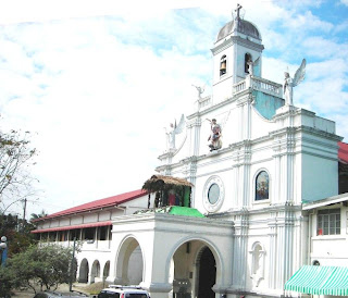
 As in most towns, in the center stands the San Miguel de
Archangel Parish church facing the Municipal town hall. Both structures are built of mortar and red
bricks which may have been imported from the neighboring province of Apalit,
Pampanga, famous for its red clay bricks. A prayer of thanksgiving and for a
safe journey home was in offing.
Not to forget, enroute home we stopped for a much needed
refueling at Jollibee located at the national highway and junction of Baliuag
where an overpass now stands, the only one of its kind in Bulacan or elsewhere
in Luzon.
The not so recognized town of San Miguel has a few other significant
places of interests worth exploring. The local government, barangays and
residents should help preserve and protect these areas, developing them with careful
environmental considerations. If well coordinated efforts are made, this not so
visited town would have a constant flow of visitors wanting to know more about
its forgotten part in Philippine history.

 We reached the Bahay
Paniki or Bat Cave. Entry is
through a large crevice, leading down to a huge chamber. The river passes
through its high vaulted openings on both ends. Thousands of bats hang on its
ceiling, squeaking and a few flying in pursuit of a better space to cling on to.


 As in the Bahay
Paniki, the entrance way was trough a gapping hole on the ground. Different
was that this cave was much smaller, super dark, no other openings other than
the entranceway, was quite slippery and muddy. Our guide lit his lamp and led
the way while I positioned myself on the rear lighting the other half of our
tracks. We saw a couple of shoe soles on the trail and wondered why they were
there. After a few minutes of keeping our shoes on our feet, we realized why. The
mud was sucking the soles off our shoes.
  As in most towns, in the center stands the San Miguel de
Archangel Parish church facing the Municipal town hall. Both structures are built of mortar and red
bricks which may have been imported from the neighboring province of Apalit,
Pampanga, famous for its red clay bricks. A prayer of thanksgiving and for a
safe journey home was in offing.


No comments:
Post a Comment