 I’ve always been a bit
anxious to travel to someplace unfamiliar, even more so if this destination
happens to be in a part of the world not frequently visited compared to their
more rapidly-developing neighbors.
I’ve always been a bit
anxious to travel to someplace unfamiliar, even more so if this destination
happens to be in a part of the world not frequently visited compared to their
more rapidly-developing neighbors.
Much to my surprise, the landscape
of the Sultanate of Oman was truly one of a kind, endowed with jagged jabals (mountains) with desolate wadis (valleys) that would surely
fascinate geologists and rock climbers of any category.
The land and the sea
within

 The Omani
coastline stretches over 3,000 km long earning its seafaring communities a
place in the history of the Arabian maritime trade. On its northern tip lies the Musandam Peninsula
overlooking the Arabian Gulf and the Sea
of Oman. A natural strategic
location, Oman has had a
controlling advantage of the 35-mile-wide Strait of Hormuz, a gateway to all
ships coming from the Indian Ocean and Arabian Sea.
The Sea of Oman continues to provide abundant
seafood to the country as seen in their fish market where large and small fresh
tuna, king mackerel, jacks, sail fish, sardines, and wild prawns dominate the
daily catch over all other reef fishes.
The Omani
coastline stretches over 3,000 km long earning its seafaring communities a
place in the history of the Arabian maritime trade. On its northern tip lies the Musandam Peninsula
overlooking the Arabian Gulf and the Sea
of Oman. A natural strategic
location, Oman has had a
controlling advantage of the 35-mile-wide Strait of Hormuz, a gateway to all
ships coming from the Indian Ocean and Arabian Sea.
The Sea of Oman continues to provide abundant
seafood to the country as seen in their fish market where large and small fresh
tuna, king mackerel, jacks, sail fish, sardines, and wild prawns dominate the
daily catch over all other reef fishes. Oman’s climate is generally hot
and humid along the coast. This weather gets drier further
inland, while summer monsoons usually affect the southern region of Salalah.
Oman’s climate is generally hot
and humid along the coast. This weather gets drier further
inland, while summer monsoons usually affect the southern region of Salalah.
Protection from the sun’s
heat, the traditional attire for men is called dishdasha, a long sleeved
ankle length white robe with head gear and leather slip-ons. The female wears a
sirwal, a floor length black long
sleeved dress with a lihaf head
scarf. The black color was introduced from Iran, replacing the more colorful
dresses in the urban areas. However, the rural villagers still wear their
traditional colors.

It was only in
1970 when Sultan Qaboos bin Sa’id initiated the modernization of Oman,
transforming dirt roads into two lane high-grade carriageways (highways)
cutting through mountains and valleys, expanded their electrification system,
built a larger airport that was once an asphalted runway on a river bed,
upgraded its sea ports, and other utility services. These changes came slowly
and cautiously as to prevent the loss of its cultural heritage and much of its
natural treasures.
55% of its 3
million population lives in its capital, Muscat
and the Batinah coastal plain northwest of the capital. About 600,000 of these are guest workers from
India, Pakistan, Bangladesh,
Egypt, Jordan, as well
as our own OFWs. Arabs, Baluchis, Zanzabaris (East Africa),
Indians, Pakistanis & Bangladesh compose the Sultanate’s ethnic groups
practicing Ibadhi (Omani version of Islam), Sunni or Shia Islam, Hinduism or
Christianity.
India’s particularly long trading history with Oman meant
Indian Rupee was once used as currency prior to the introduction of the Omani
Rial.

 Muscat
Once a walled city, the Portuguese colonists transformed Muscat as a base. Stone and mud watch towers built on the surrounding mountains augmented its natural fortifications On its northern side, a cove faces the Gulf of Oman with two fortresses called Mirani & Jalali built on mountain tops at opposite points. Curfews were enforced, as the main gate to the city closed in the early evening and opened again at sunrise. Other than the two fortresses, today the walls no longer exist replaced with a symbolic modern road archway housing a museum showcasing its history. A modern Sultan’s Palace and other ministerial offices are now standing in this area, called Old Muscat.
The Persians, French and
British also set foot in Oman.
The latter were the only adventurists who, in a way succeeded by establishing
several treaties of friendship and commerce lasting up to the present
time. They provided security to the
Monarchy, preventing further tribal uprisings from succeeding. They supported
the 1970 palace coup when Sultan Qaboos bin Sa’id over threw his father from
power. Finally, the British influence has expanded into their vocabulary, as
much of their road signage refers to terms often used in Britain. There
are only two radio stations that air western music daily, with male and female
DJ’s with British accents.


Oman was not entirely a reclusive nation. It too ventured
outside its borders occupying east Africa’s coast, from Mombasa
onwards, Zanzibar, and other places in the
southern Arabian Peninsula.
Nearby
Districts of Muscat
 Muttrah
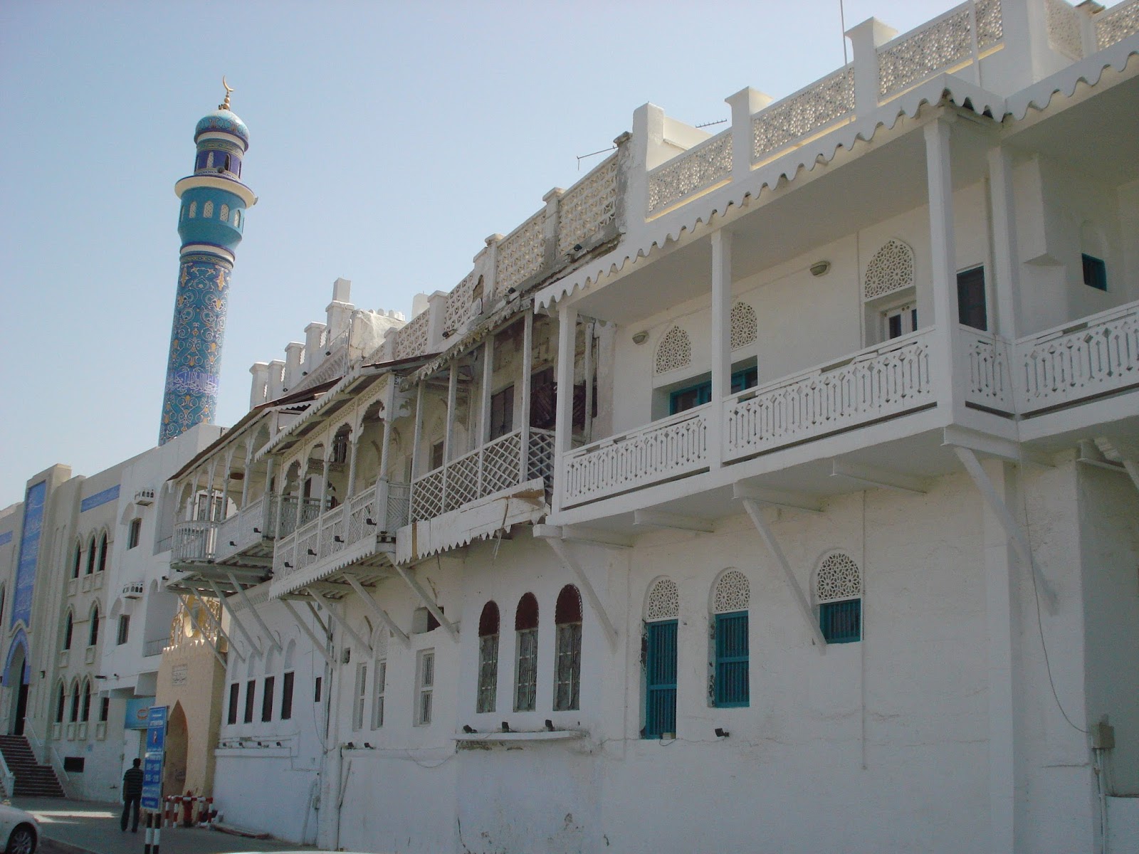 Equivalent to Manila’s port area, Muttrah is Oman’s oldest commercial center. It
served as a storage area for goods that were unloaded in old Muscat before being distributed in the
interior. Over the centuries, Muttrah grew into a home and business hub for merchants.
Today it has also turned into a tourist attraction with its new souq (market), a wide street converted
into a marketplace connecting the new and old market areas selling both modern
and traditional goods. Store hours in Oman are from 9AM-12PM, and 4-8PM. Store
hours are shorter on the Islamic weekend of Thursday and Friday.
Equivalent to Manila’s port area, Muttrah is Oman’s oldest commercial center. It
served as a storage area for goods that were unloaded in old Muscat before being distributed in the
interior. Over the centuries, Muttrah grew into a home and business hub for merchants.
Today it has also turned into a tourist attraction with its new souq (market), a wide street converted
into a marketplace connecting the new and old market areas selling both modern
and traditional goods. Store hours in Oman are from 9AM-12PM, and 4-8PM. Store
hours are shorter on the Islamic weekend of Thursday and Friday.  On top of the souq’s mountainside stands the Muttrah
fort, a historical landmark expressing a mighty force to once-foreign aggressors
approaching its port.
On top of the souq’s mountainside stands the Muttrah
fort, a historical landmark expressing a mighty force to once-foreign aggressors
approaching its port. A few minutes walk along
the granite cornice or seaside
walkway is the port
of Oman where a small
fish market is also located. Local
fishermen drop their early morning catch from nearby reefs. Adjacent is a vegetable and fruit market filled with both local and imported harvests
including kangkong, bayabas, saluyot, calamansi, and puso ng saging, among others.
A few minutes walk along
the granite cornice or seaside
walkway is the port
of Oman where a small
fish market is also located. Local
fishermen drop their early morning catch from nearby reefs. Adjacent is a vegetable and fruit market filled with both local and imported harvests
including kangkong, bayabas, saluyot, calamansi, and puso ng saging, among others.
 Ruwi
Ruwi
Oman’s business center is now located in Ruwi, a valley
behind Muttrah’s mountain ridge. Here lies the financial district, Ruwi souq
(bargain stores), PC stores, sports shops, car parts & repair, home
furnishings, electronic appliances and repair, airline and travel agencies,
supermarkets, hotels and numerous businesses drive this area abuzz. This is also where the one and only Filipino
“Palayok” restaurant is located, serving Omans’ growing army of OFWs.


Oman is one the few Arab states that allows worship of
other denominations, however none of these denominations may outwardly display
their symbols such as crosses. City authorities have allocated places of
worship for Christians, which include St. Peter & Paul Church for Roman
Catholics and the Bible
Center for other
Christians. Worship services follow both the Islamic and Christian weekends.
Malls and Hypermarkets

Rich in oil and natural
resources, Oman
is still an import-dependent nation. Almost all of its food supplies come from
neighboring states, East Asia, Africa, and
western countries. There are several hypermarkets, the most popular of which
are Lulu’s, Khimji’s and Al Fa’ir with stocks as varied as their western
counterparts.
 The most frequented
shopping mall is the French-owned chain Carrefour. Filled with high-end Western name-brand
stores, Oman
has two of these malls, the larger one located in Seeb close to the airport.
The most frequented
shopping mall is the French-owned chain Carrefour. Filled with high-end Western name-brand
stores, Oman
has two of these malls, the larger one located in Seeb close to the airport. Land and Seascape
 Oman’s brownish gray mountains and white buildings
dominate the color of its landscape. Along its roadway developments lie
thousands of kilometers of sprinkler systems allowing grass lawns, palm date trees, and other
flowering plants to grow giving Oman a greener and cooler look. The Sea of Oman’s
deep blue horizon contrasts with the landscape with its turquoise coves and
glaring beige sandy beaches with limestone cliffs.
Oman’s brownish gray mountains and white buildings
dominate the color of its landscape. Along its roadway developments lie
thousands of kilometers of sprinkler systems allowing grass lawns, palm date trees, and other
flowering plants to grow giving Oman a greener and cooler look. The Sea of Oman’s
deep blue horizon contrasts with the landscape with its turquoise coves and
glaring beige sandy beaches with limestone cliffs. 
Southeast Coastline
 Driving in Oman is a treat
because of its well paved highway system and a good choice of rental vehicles.
My road travel companions were from Indonesia,
Hong Kong and the Philippines.
Our first out of town trip was to the city of Sur-
once an old wood boat-building town, 337 kms southeast of Muscat.
Driving in Oman is a treat
because of its well paved highway system and a good choice of rental vehicles.
My road travel companions were from Indonesia,
Hong Kong and the Philippines.
Our first out of town trip was to the city of Sur-
once an old wood boat-building town, 337 kms southeast of Muscat.  Qurayyat
Halfway towards Sur is the
popular Wadi Dayqah, a wide river fed by a gigantic dam upstream. Applying the
traditional irrigation canal system, the dam feeds sufficient water downstream
to small farms along the river bank. Local family barbecue picnics are held
under the wadi’s palm date trees, while natural pools serve the more
adventurous swimmers. Ruins of old mud houses are found in nearby villages.


In the center of
Qurayyat’s town is a small fort which once stood to watch over its
territory. Quite rustic and filled with
artifacts, the fort now serves as a reminder of the town’s old traditions.


Wadi (valley)
Another beautiful site is
Wadi Ash Shab, a seaside oasis located along the river mouth whose sides are
lined with palm date trees and sheer mountain cliffs where the locals enjoy
spending their weekend family picnics.

Sur
Sur’s town proper has a
hill where the Sunaysilah fort
stands. Although it doesn’t seem so large from the inside, the fort still
dominates the town’s landscape.
Though not as developed
and densely populated as Muscat, Sur’s residential houses and seaside streets
are all new, and the town no longer bears the image of a fishing village.

One of the important
itineraries in travelling is a taste of the local dish. A lunch menu such as: maqbous - rice with saffron, Ruhal – platter-sized oven-baked flat
bread, fresh vegetable salad with hummus
dressing, stewed mutton, and fresh fish in spicy tomato sauce was a delicious
treat. One has the option of eating the Omani traditional way: seated on a
carpeted floor, with a shared meal served on a single large plate and using
your bare fingers to eat.

Turtle Dunes
25 minutes further south
is Raz Al Jinz Natural Reserve where thousands of green turtles lay eggs from
June up to September. Oman
has taken preservation measures in this area by isolating 45 km of coastline
and 1 km outwards from poachers and offering regulated guided tours, leaving
nature take its course.

Inland
 Nizwa
Nizwa
Travelling on another day,
we set-off 160km northwest of Muscat towards the
interior of Oman - the city
of Nizwa, its
largest province.
In its center stands the
Nizwa fort. Built sometime in the late 16th century, the fort’s
tower rises 35 meters high with a circumference of 45 meters. It is the largest
fort tower in the Sultanate.
The tower is a
massive sight from afar. Its cannon equipped sentinel provided a 360-degree
view of the city. Access to the top is only by means of a narrow, zigzagged
staircase barred by a heavy wooden door studded with metal spikes. Its stairway
has false flats built with traps pits with sharp metal stakes to ensnare  the
enemy or impede their way to the top of the tower.
the
enemy or impede their way to the top of the tower.
 the
enemy or impede their way to the top of the tower.
the
enemy or impede their way to the top of the tower.
Those who did
manage to escape these hurdles risked being shot or burnt by boiling date syrup
poured through shafts directly above each set of doors.
The fort has a
deep well, food supply and ammunition storage rooms to last its occupants for a
long siege.
Outside the
fort is a more modern souq where one
can shop for local clay potteries,  antiques including authentic tribal rifles,
bullets and kanjar (curved daggers),
silver bangles, rings, incense burners, fruits, vegetables and fish. Alongside
rests the remnant mud walls of the old souq, a reminder of the past settlers
doing business outside the fort.
antiques including authentic tribal rifles,
bullets and kanjar (curved daggers),
silver bangles, rings, incense burners, fruits, vegetables and fish. Alongside
rests the remnant mud walls of the old souq, a reminder of the past settlers
doing business outside the fort.
 antiques including authentic tribal rifles,
bullets and kanjar (curved daggers),
silver bangles, rings, incense burners, fruits, vegetables and fish. Alongside
rests the remnant mud walls of the old souq, a reminder of the past settlers
doing business outside the fort.
antiques including authentic tribal rifles,
bullets and kanjar (curved daggers),
silver bangles, rings, incense burners, fruits, vegetables and fish. Alongside
rests the remnant mud walls of the old souq, a reminder of the past settlers
doing business outside the fort.
Although we had
lunch in a local Pizza Hut, their large calzone with chicken or meatballs had a
distinct Omani flavor.


Jabal
(Mountain)
 Bahla
Bahla
After a hearty
meal, we headed for Jabal Al-Shams, famous for its mountain
view similar to the Grand Canyon.
Missing a turn and came across a small town called Bahla, whose own fort stood
beside the main highway. Currently being reconstructed, UNESCO lists this fort
as a national heritage site. Remnants of the original mud and stone riverbank
walls still stand, adding a more rustic look to the fort’s surroundings.


Al Hamra
After 40 mins
of search for the right turn-off we headed back towards Nizwa and finally found
the Al Hamra T-junction to Jabal Al-Shams. The winding foothills had groups of
houses that emerge every two kilometers. These settlements also had bare-dirt
football fields where groups of boys can be found playing the game.
 We stopped to
see a village built of stone walls perched on a mountain side opposite the
roadway. A spectacular view.
We stopped to
see a village built of stone walls perched on a mountain side opposite the
roadway. A spectacular view.  We drove down
the loose gravel road and crossed the dry riverbed towards the village. On its
foot lies a small green farm patch fully irrigated. A rocky foot path leads up
to the stone village. Though empty, most of the house walls, doorways, windows
and remnants of its near collapsed wood, palm leaf and mud roof stood still
frozen in time. As you walk through the rooms and the main pathway, you can’t
help but imagine the activities that transpired in them.
We drove down
the loose gravel road and crossed the dry riverbed towards the village. On its
foot lies a small green farm patch fully irrigated. A rocky foot path leads up
to the stone village. Though empty, most of the house walls, doorways, windows
and remnants of its near collapsed wood, palm leaf and mud roof stood still
frozen in time. As you walk through the rooms and the main pathway, you can’t
help but imagine the activities that transpired in them.Not wanting to leave, we decided to move on and drove back to the main road further up the mountains. After half an hours drive, the well asphalted road ended. Without any road signs pointing to our destination, we cruised along the winding road with ravines with outgrowth of shrubs and other plants.


 Reaching a higher
altitude, we saw from across the cliff a green terraced area similar to our
rice terraces, but just a speck against the bare mountain side. We did not
check it out and drove further up. Cement road finally reappeared and after a few kilometers we reached what seemed to be the
summit. Spectacular it was barren mountains, deep gorges and clear skies all around. After an hour or so we decided to turn back to Nizwa. The peak had
smooth, flat volcanic like boulders with littered shrub out growth on the lower plateaus and a few campers
pitched tents alongside the sparse leaf shade.
Reaching a higher
altitude, we saw from across the cliff a green terraced area similar to our
rice terraces, but just a speck against the bare mountain side. We did not
check it out and drove further up. Cement road finally reappeared and after a few kilometers we reached what seemed to be the
summit. Spectacular it was barren mountains, deep gorges and clear skies all around. After an hour or so we decided to turn back to Nizwa. The peak had
smooth, flat volcanic like boulders with littered shrub out growth on the lower plateaus and a few campers
pitched tents alongside the sparse leaf shade. 
We reached Nizwa just before sundown, went around its souq then headed back to Muscat.


Diving in Sea of Oman
Dimaniyat Islands

 The most popular scuba diving site in the
Sultanate is the Dimaniyat group of Islands.
Located northwest off Muscat
shores; the islands can be reached via speed boat. I joined a regular dive excursion
organized by Global Dive Shop operating beside the Muscat International
Airport. We boarded a
Yamaha work boat type speed boat powered by twin 150HP Yamaha outboard engines.
After 45 mins of travel time we reached the Dimaniyat and anchored north of the
Police Island. The Dimaniyat islands are a
protected area, off limits to commercial fishing, but open to sport fishing.
From April to September it is prohibited to land on the islands due to the
nesting season of the shore birds. The island didn’t have any sign of trees.
The most popular scuba diving site in the
Sultanate is the Dimaniyat group of Islands.
Located northwest off Muscat
shores; the islands can be reached via speed boat. I joined a regular dive excursion
organized by Global Dive Shop operating beside the Muscat International
Airport. We boarded a
Yamaha work boat type speed boat powered by twin 150HP Yamaha outboard engines.
After 45 mins of travel time we reached the Dimaniyat and anchored north of the
Police Island. The Dimaniyat islands are a
protected area, off limits to commercial fishing, but open to sport fishing.
From April to September it is prohibited to land on the islands due to the
nesting season of the shore birds. The island didn’t have any sign of trees. We dove off its northern
side. The water was still, temperature
was comfortable and visibility was 10m across. The reef was intact with
plentiful reef fishes. However, the dominant colors were brown and yellow, the latter
from the schools of yellow grant fish that hovered all over place. A one of a
kind pastel blue coral polyp colonies added accent to Dimaniyat’s reef.
We dove off its northern
side. The water was still, temperature
was comfortable and visibility was 10m across. The reef was intact with
plentiful reef fishes. However, the dominant colors were brown and yellow, the latter
from the schools of yellow grant fish that hovered all over place. A one of a
kind pastel blue coral polyp colonies added accent to Dimaniyat’s reef.
While enjoying the balmy
weather on board, we ate fresh salad, sandwiches and fruit juice for lunch.
 After an hours rest, we
transferred our anchor on the south side of the same island. The water
condition was the same as in our first dive. This time we saw a 5-foot leopard
shark resting with a resident remora cleaner fish, a pair of large cuttlefishes
mating, a full grown spiny green lobster, fully grown honeycomb moray eels,
flat fishes, and other reef fishes. Abundant again were schools of yellow
grants and the blue coral polyp colonies.
After an hours rest, we
transferred our anchor on the south side of the same island. The water
condition was the same as in our first dive. This time we saw a 5-foot leopard
shark resting with a resident remora cleaner fish, a pair of large cuttlefishes
mating, a full grown spiny green lobster, fully grown honeycomb moray eels,
flat fishes, and other reef fishes. Abundant again were schools of yellow
grants and the blue coral polyp colonies. We finished diving around
1:30PM then headed back to Muscat.
We finished diving around
1:30PM then headed back to Muscat.
Sinkhole
Oman has surprising unique
seaside attractions. One of which is the Bamah “Sinkhole”. Located before reaching Sur, this natural
site is about 300 meters from shore, whose hole is about 50m in diameter and
30m deep, 2/3 filled with turquoise seawater coming from a natural tunnel
connected to the sea. Wading in the water provides some foot relief with tiny
fishes nipping the dead skin off your feet.
 Snorkeling on the deeper
end, one can find fresh water guppies thriving along the 1-2 feet deep edges of
the water where small soft purple and yellow sponges also grow. The presence of these fresh water fish may be
due to the inability of the sink hole to fully drain during low tide
accumulating fresh water from decades of rainfall.
Snorkeling on the deeper
end, one can find fresh water guppies thriving along the 1-2 feet deep edges of
the water where small soft purple and yellow sponges also grow. The presence of these fresh water fish may be
due to the inability of the sink hole to fully drain during low tide
accumulating fresh water from decades of rainfall.
The Bamah Sinkhole is a
protected site secured in a park with minimal facilities for camping and
picnics.


 Intrigued by the abundant
catch in Muttrah’s fish market and clear water off the port, we decided to go
snorkeling in the cove beside Kalbooh Park. Located between Muttrah and Old
Muscat, Kalbooh cove offers beachcombers, swimmers and snorkelers’ an easy
encounter with Oman’s marine life. The
occasional flock of shorebirds likes to swoop down on unwary fish fingerlings,
and green parrots feed on nearby palm date trees. A variety of mollusk shells
(dominated by olive shells) lay on shore, while the clean and clear water is
teeming with marine fauna: deep electric blue surgeon fish with orange tails,
orange lemon fish, parrot fish, juvenile jack fish, pompano, goat fish, striped
and silver damsels, cuttle fish, yellow grants, stingrays, flat fish,
occasional manta and barracudas, sabalo, and lots of banaks and dalagang bukid.
Intrigued by the abundant
catch in Muttrah’s fish market and clear water off the port, we decided to go
snorkeling in the cove beside Kalbooh Park. Located between Muttrah and Old
Muscat, Kalbooh cove offers beachcombers, swimmers and snorkelers’ an easy
encounter with Oman’s marine life. The
occasional flock of shorebirds likes to swoop down on unwary fish fingerlings,
and green parrots feed on nearby palm date trees. A variety of mollusk shells
(dominated by olive shells) lay on shore, while the clean and clear water is
teeming with marine fauna: deep electric blue surgeon fish with orange tails,
orange lemon fish, parrot fish, juvenile jack fish, pompano, goat fish, striped
and silver damsels, cuttle fish, yellow grants, stingrays, flat fish,
occasional manta and barracudas, sabalo, and lots of banaks and dalagang bukid.
 The longer sides of the
original cove had been reclaimed to accommodate a wider roadway from Muttrah to
Old Muscat and a public park was constructed on the opposite side. A local
diver recalled how these developments destroyed the coral reefs that once
resided under them. However, the cove’s sea walls were then reinforced with
cement “jack stone” breakers providing a new home for fishes to breed and good
anchorage for new corals.
The longer sides of the
original cove had been reclaimed to accommodate a wider roadway from Muttrah to
Old Muscat and a public park was constructed on the opposite side. A local
diver recalled how these developments destroyed the coral reefs that once
resided under them. However, the cove’s sea walls were then reinforced with
cement “jack stone” breakers providing a new home for fishes to breed and good
anchorage for new corals.


 Yiti and Sifah Beach
10 minutes from Muscat is a small fishing village of Yiti. On weekends, Omani women with their colorful sirwal gather outside a neighbors house for their friendly chats.
15 minutes past the village of Yiti is Sifah Beach, a future site for a five star hotel in competition with Shangri-la Resort. Often visited by local weekend tourists, this stretch of light sandy beach offers everyone a guaranteed relaxing treat.

The drive alone a scenic mountain
route, passing by several intertidal coves, adds pleasure to the journey to Sifah.
Seeing Sifah’s clear azure waters is an irresistible call for snorkeling. Although the intertidal and shallow reef is basically composed of mineral ore rocks and dead corals, still thrives Oman’s marine treasures: marble groupers, goat fish, green turtles and eagle rays.


 Sultan Qaboos Grand Mosque
10 minutes North of the city sprawls the Sultan Qaboos Grand Mosque in a 46 hectare land. Constructed in 1995, the Grand Mosque is built of 300,000 tons of Indian Sandstone. The Mosque took 6 years to
complete. The musalla or main prayer hall's carpet took four years to
complete. It is said to be the second largest single piece carpet in the
world hand made by an Iranian carpet company.


Responsible Tourism
Although there’s still
much room for environmental considerations, the Sultanate of Oman has placed a
high value on preserving its national heritage thus using a development
platform of responsible tourism. Its tourism infrastructure is one its major
investments knowing that the rest of the world especially those who appreciate
adventure with history will be listing Oman on top of their travel
itinerary.
Numerous local tour operators offer different
activities such as: desert dune or island campouts, dolphin or turtle watch,
scuba and skin diving, 4x4 driving, cave tours and other adventure activities
complete with catered buffet meals or scheduled meal stops. Car rental companies are easily accessible
with affordable sedans, AUV’s, 4x4’s and light pick-up trucks to choose from.
Note: museums are close on weekends (Thursdays & Fridays).
Of course, nothing beats venturing on your own
with a rented 4WD vehicle not pressed for time enjoying more of Oman’s exciting
back roads filled with surprises. As always, ending a day’s tour in the
Sultanate leaves you more anxious wanting to see and know more about its
colorful heritage.


